Google Earth instead of Trowel and Brush:
By Tobias Wenzel |
|
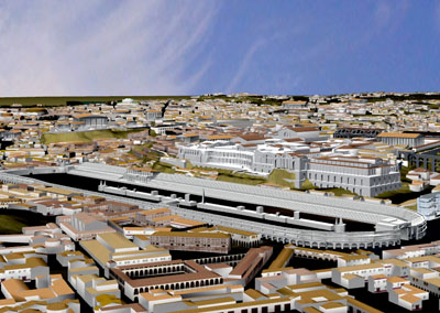
For modern archaeologists, internet access has become as indispensable a working tool as the trowel. With Google Earth, they can survey far-flung parts of the Earth in search of promising excavation sites, without expensive travel costs. Scholars at the "Computer Applications in Archaeology" conference in Berlin discussed the attractions of the computer era. Bernard Frischer of the University of Virginia is a modern archaeologist. He does not dig in the sand, but rather looks at his laptop. A video file plays, with music in the background. A huge virtual city can be seen: "We're about to take a flight over the entire ancient city of Rome, in the year 320 B.C. We're now seeing the city from the east, with thousands of buildings. Now we're approaching the city center. I see the Temple of the Divine Claudius and the Colosseum." A student of ancient languages and archaeology, Bernard Frischer has for the last ten years, with his colleagues, worked to bring ancient Rome to life again on the computer. In Berlin he invited conference attendees to take a virtual trip to the ancient city. Many pixel-laden rooms are accessible. Soon a colossal statue of Constantine will stand in the computer-generated Basilica Maxentii. The head of a digital archaeology company, who created the 3D version of the statue, has recently been in touch with Bernard Frischer. Frischer: "So we made an agreement to swap, so that he gets our Basilica and we get the statue. The statue enhances our Basilica and vice versa. I hope that this type of framework agreement occurs between corporations, scholars, and museums. They would extend and enrich this 3D model of Rome." In addition, Frischer would like to link the virtual ancient Rome with satellite photos of modern Rome. With the help of free Google Earth software. Google Earth has revolutionized the work of many archaeologists, including that of Scott Madry. The professor of Anthropology at the University of North Carolina has tested the digital tools extensively in Burgundy, as he tells attendees at his Google Earth workshop at the Berlin conference: "I have worked in this region for 25 years, and I have found perhaps 20 archaeological sites. But in only one month I have discovered 100 sites, while working at home or in the office, using Google Earth and flying by virtual helicopter around the study area." Previously, archaeologists took off in real helicopters, to areas where they supposed archaeological sites might be. Today, Google Earth takes the place of most of these flights. Archaeologists can zoom in to a level of a few meters, sometimes only centimeters, to specks of earth, Scott Madry knows: "We have several indicators of archaeological sites, such as changes in vegetation or the soil, in the form of a line, rectangle, or circle. If I discover such a thing with Google Earth, I transmit the position information to my GPS receiver. In the field the system then leads me to within a few meters of the site. Sometimes the supposed sites are of course modern water or sewer lines. But very often one can find new, undiscovered archaeological sites. "Then archaeologists can inform local authorities, so that historical places are at once protected. Against the backdrop of these fascinating computer applications, Bernard Frischer of the University of Virginia is already worrying whether there will still be enough conventional archaeologists in the future: "We always need people who just love to sit in the trench and pull finds out of the dirt. Most people are interested in the sexy things, like the 3D models." |
|